


A group of elementary-aged students gathered outside the Oldham County Public Library in La Grange, Kentucky, to gaze at the clouds. “If anyone asks what you are doing, tell them, ‘I am a citizen scientist and I am helping NASA,'” said Cheri Grinnell, Children’s Programming Librarian. Grinnell leads an afterschool program called Leopard Spot, engaging K-5 students in collecting environmental data through the GLOBE (Global Learning and Observations to Benefit the Environment) Program.
The excitement was palpable when one young participant told his mother he was working for NASA. This enthusiasm was further fueled when the program received an email from NASA with satellite data that matched the students’ cloud observations. “I forwarded the NASA satellite response to the after-school coordinator, and she read it to them. That really excited them because it was evidence this is the real deal,” Grinnell noted.
Connecting Ground Observations with Space Data
This experience is not unique. The GLOBE Observer Team, part of NASA’s Science Activation program’s NASA Earth Science Education Collaborative (NESEC), often hears similar stories. Volunteers of all ages are thrilled to receive emails from NASA comparing satellite data with their cloud observations. “Feedback from NASA is huge. It’s the hook,” explained Tina Rogerson, a programmer at NASA Langley Research Center who manages these satellite comparison emails. “It ties NASA science into what they saw when they did the observation.”
In a recent development, GLOBE announced an expansion of this initiative. Volunteers will now receive emails comparing their land cover observations with satellite data, in addition to cloud observations. This new feature builds on the existing system at NASA Langley Research Center, offering a more comprehensive view of Earth’s changing landscapes.
How the New System Works
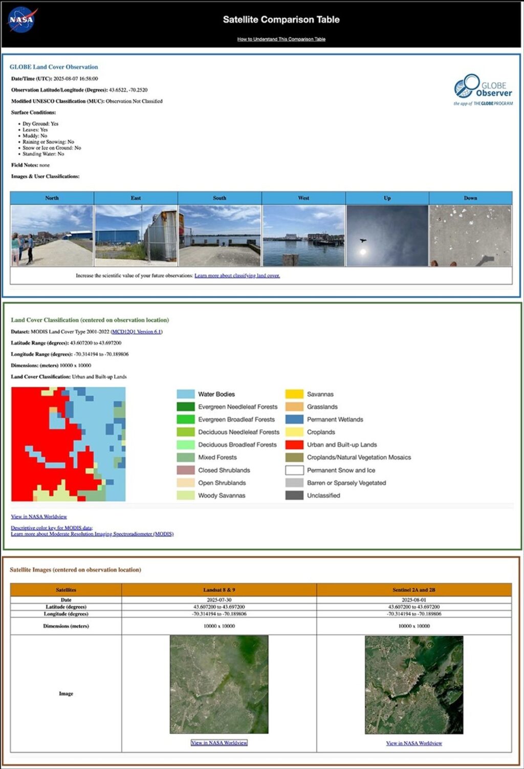
When volunteers receive the email, they will find a link for each observation submitted. This link opens a website featuring a satellite comparison table. The table displays the volunteer’s observation at the top, followed by a satellite-based assessment of the land cover at that location. The final row showcases the most recent Landsat and Sentinel-2 satellite images of the observation site. Rogerson generates and sends these comparison tables weekly, drawing from the public GLOBE database.
While participants can opt out of these emails, most are eager to review their data from a space perspective. These new collocated land cover observations are expected to enhance awareness of how NASA and its partners monitor our planet from space, ultimately informing societal needs.
The Impact of Citizen Science
These initiatives not only empower volunteers but also contribute to GLOBE’s long-term environmental record. By seeing their observations in the context of a broader, space-based view, volunteers gain a deeper understanding of their role in the scientific process. “I’m excited that land cover is finally becoming part of the operational satellite comparison system,” Rogerson expressed. This expansion means GLOBE volunteers will routinely receive satellite data for both land cover and clouds, bringing real science into their world.
The move represents a significant step in encouraging citizen scientists to continue contributing to Earth system observations. The hope is that these efforts will inspire more individuals to participate in NASA’s mission, fostering a greater connection between people, land, and space.