


Kyoto, Japan — Forests have long been vital to humanity, offering essential ecosystem services such as carbon storage, timber, recreation, and climate regulation. However, accurately assessing forest biomass has been a challenging task due to the vast and complex nature of forest structures. Traditional ground-based surveys are labor-intensive and often impractical in remote or steep terrains, limiting large-scale assessments. This has hindered the development of precise biomass estimation models.
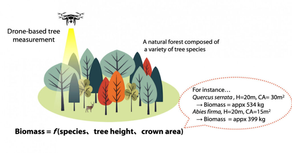
Recent advancements in drone-based technologies, particularly LiDAR (Light Detection and Ranging), are transforming how researchers study forests. LiDAR emits millions of laser beams per second to obtain detailed three-dimensional information about objects, making it an invaluable tool for measuring tree structures and forest biomass.
Revolutionary Study by Kyoto University
A team of researchers at Kyoto University has leveraged LiDAR technology to conduct an extensive forest survey across Japan. They measured the crown structure of 4,326 canopy trees, representing 149 species, across 23 forest census plots from Hokkaido’s sub-boreal forests to Okinawa’s subtropical ones. By integrating drone-derived data with detailed ground measurements, the team developed species-specific equations to estimate tree biomass based on crown structural traits.
“To our knowledge, this represents the most comprehensive study to date estimating biomass for such a large number of tree species using drone-based data,” says first author Kyaw Kyaw Htoo.
Key Findings and Methodology
The analysis revealed that a model using only tree height and crown area could explain 72% of biomass variation. When functional types such as conifer, deciduous broadleaf, and evergreen broadleaf were included, the explanatory power increased to 79%, further improving to 83% with species-level information.
“Though drones cannot directly capture understory trees, our study found that canopy trees account for about 75% on average of total forest biomass across diverse forest types,” notes team leader Yusuke Onoda. “These results provide a foundation for estimating total forest biomass, including the understory.”
This approach offers a repeatable, scalable, and data-driven tool for long-term forest monitoring and evaluation. It holds potential for improving carbon credit accuracy and biodiversity monitoring, marking a significant step forward in sustainable forest management.
Implications for Sustainable Forestry
The adoption of drone-based LiDAR technology in forest biomass assessment is a game-changer. By providing more accurate and efficient measurements, it enhances forest resource assessments and aids in biodiversity conservation. This technology also supports the promotion of sustainable forestry practices, which are crucial in the fight against climate change.
“By making good use of these tools, we aim to enhance the efficiency of forest resource assessment, and hope to contribute not only to scientific progress but also to biodiversity conservation and to promoting sustainable forestry,” says Htoo.
The study’s findings underscore the importance of integrating advanced technologies in environmental research. As the world grapples with climate change and biodiversity loss, such innovative approaches are essential for informed decision-making and policy development.
Looking ahead, the research team plans to expand their study to include more diverse forest types and regions, further refining biomass estimation models. This ongoing work promises to contribute significantly to global efforts in forest conservation and management.