

An Australian woman who rescued “two tiny fluff balls” during a violent storm has urged fellow citizens to be vigilant about wildlife on their properties as the country braces for more “unusual” and potentially destructive weather. This year has already been marked by extreme conditions.
From relentless rainfall to record-breaking temperatures and snowfall occurring simultaneously, and even a rare November cyclone, Australians are left wondering about the erratic climate patterns. The confusion is unlikely to subside soon.
A negative Indian Ocean Dipole (IOD) is currently influencing weather patterns, leading to a wetter-than-average summer. There are warnings that supercell thunderstorms are becoming “more frequent.” Meanwhile, the Bureau of Meteorology (BoM) has indicated signs that La Niña may be developing.
Homeowners Urged to Act After Wild Storms
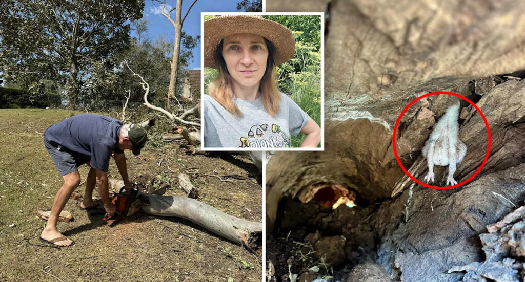
Alana, a wildlife carer from the outskirts of Toowoomba in west Queensland, was relaxing at home when an unexpected storm struck on a quiet Sunday afternoon last month. “We had no warning,” she recounted, describing the storm’s fierce winds and hail.
Once the storm passed, Alana ventured outside to find “massive” trees and branches scattered across properties and roads, with powerlines downed. Concerned about wildlife, she urged her community via WhatsApp to inspect their properties for injured animals.
Hours later, a neighbor discovered young boobook owls in a fallen tree and called Alana for assistance. She found two surviving owlets and two others that had died on impact. The incident highlighted a lack of awareness about the environmental significance of hollow nesting trees.
The next day, Alana was seen door-knocking and stopping chainsaw operators to check for wildlife in fallen trees. Her efforts saved “two tiny fluff balls just in time,” emphasizing the importance of checking hollow-bearing trees and logs after storms.
Weather Patterns and La Niña Developments
Spring and summer typically bring more storms, with supercell thunderstorms becoming more common during warmer months. According to Weatherzone, supercells are the “most dangerous” type of storm, characterized by towering, rotating formations.
Dr. Milton Speer, a meteorologist and visiting fellow at the University of Technology Sydney, noted that these storms are becoming more frequent. The BoM’s recent observations suggest a potential La Niña development, which the US Climate Prediction Center has already confirmed as underway.
La Niña is a weather phenomenon that results in cooler Pacific Ocean temperatures, typically leading to increased rainfall and more frequent storms across much of Australia.
The BoM has stated that the El Niño–Southern Oscillation (ENSO) remains neutral, but recent models suggest La Niña conditions could persist until January before returning to neutral. The likelihood of BoM confirming La Niña has increased due to changes in how sea surface temperatures are calculated.
Potential Impacts and Future Precautions
Dr. Andrew Watkins, former head of long-range forecasts at the BoM, explained that while La Niña conditions have been near borderline, other climate drivers like the negative Southern Annular Mode (SAM) have influenced atypical impacts. He noted, however, that further development might be limited.
While the impacts are unlikely to match the three consecutive La Niña events from 2020 to 2022, Watkins advised Australians to remain vigilant for tropical lows or cyclones that could develop in the warmer waters surrounding the country, potentially leading to significant rainfall.
As Australia continues to navigate these challenging weather patterns, Alana’s story serves as a reminder of the importance of community awareness and action in protecting both human and wildlife populations during extreme weather events.