


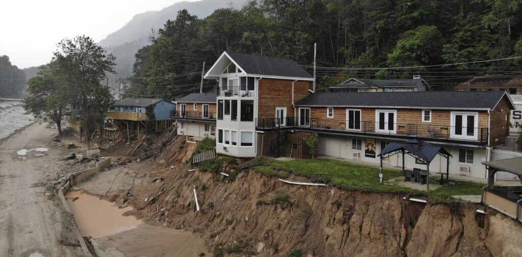
Hurricane Helene, which swept through the Southeastern United States in September 2024, left a lasting impact that extends far beyond its brief lifespan. The storm triggered mudslides that buried roads and reshaped river channels, while uprooted trees exposed hillslopes to erosion. Sediment washed into rivers altered water flow, increasing the risk of future flooding and erosion. This serves as a powerful reminder that natural hazards do not simply disappear once the skies clear; they evolve.
These changes are part of what scientists refer to as cascading hazards. Such hazards occur when a natural event alters the landscape in ways that lead to future risks. For example, a storm-induced landslide might clog a river, leading to downstream flooding months or even years later. Similarly, a wildfire can change soil and vegetation, setting the stage for debris flows with subsequent rainstorms.
The Science Behind Cascading Hazards
Understanding cascading hazards requires a grasp of the continuous physical processes that shape our landscape, such as sediment movement, weathering, and erosion. These processes are constantly at work, driven by interactions between the atmosphere, biosphere, and the earth itself. For instance, earthquakes can fracture rock and dislodge soil, priming the ground for future landslides during rainstorms.
Historical events illustrate this phenomenon. After the 2008 earthquake in Sichuan Province, China, debris flows surged long after the seismic activity had ceased. Similarly, the 1950 Assam earthquake in India triggered thousands of landslides. The sediment from these landslides gradually moved through river systems, eventually causing flooding and altering river channels in Bangladesh two decades later.
“Earth’s surface retains a ‘memory’ of these events, with sediment disturbed in an earthquake, wildfire, or severe storm moving downslope over years or even decades.”
An Intensifying Threat in a Changing World
The increasing frequency and severity of natural disasters present significant challenges for emergency planning and insurance. In California, repeated wildfire-mudslide combinations have led some insurers to withdraw from the state, citing mounting risks and rising costs. These cascading hazards are not new, but their impact is intensifying due to climate change and urban expansion into hazard-prone areas.
Climate change is exacerbating the frequency of wildfires, storms, and extreme rainfall. At the same time, urban development continues to encroach on steep, vulnerable terrains, exposing more people and infrastructure to evolving risks. The interconnected nature of these climate disasters is overwhelming systems designed for isolated events.
However, climate change is only part of the equation. Earth processes, such as earthquakes and volcanic eruptions, also trigger cascading hazards with long-lasting effects. For example, more than four decades after Mount St. Helens erupted in 1980, the U.S. Army Corps of Engineers continues to manage ash and sediment to prevent increased flood risk in downstream communities.
Rethinking Risk and Building Resilience
Traditionally, hazard risk has been estimated by examining past events. However, when landscapes change, the past may no longer offer a reliable guide for the future. To address this, scientists advocate for computer models based on the physics of these events to forecast hazard evolution in real-time, akin to how weather models update with new atmospheric data.
Advancements in Earth observation technology, such as satellite imagery, drones, and lidar (which uses light similar to radar), now allow scientists to track changes in hillslopes, rivers, and vegetation post-disaster. These observations feed into geomorphic models that simulate sediment movement and predict where future hazards may emerge.
“Cascading hazards reveal that Earth’s surface is not a passive backdrop, but an active, evolving system. Each event reshapes the stage for the next.”
Understanding these connections is crucial for building resilience, enabling communities to withstand future storms, earthquakes, and debris flow challenges. Improved forecasts can inform building codes, guide infrastructure design, and refine risk management strategies. They help communities anticipate long-term threats and adapt before the next disaster strikes.
Ultimately, these insights challenge us to think beyond the immediate aftermath of a disaster and recognize the slow, quiet transformations that build toward the next. By acknowledging and preparing for these evolving risks, we can better protect communities and infrastructure from future hazards.